Saturday, July 25, 2015

Iceland Part II: Skogafoss, Solheimjokull Glacier, a plane crash site, and Reynisfjara Beach

Wow, did we have a lot to see on our drive to Vik! Vik is about an hour away from the ferry, but it took us about four hours to get there due to some sights we wanted to see on the way.

Our first stop was to the impressive Skogafoss waterfall, which stands about 60 meters tall and is about 25 meters wide. The waterfall has a lot of power to it and you can hear the thundering of the bottom of it from afar. We were pretty surprised that we were able to get so close to the base of it given how forceful it is. We walked up to about as far as we could get without getting soaking wet. After all, we did have a lot to do that day!


Stairs and a path next to the waterfall led us all the way to the top (as well as testing our fitness) to some precarious views down below. These stairs also mark the start of one of the most popular hiking trails in Iceland, taking you 55 kilometers to Landmannalaugaur.


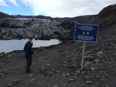
Next we drove about 20 minutes to Sólheimajökull glacier. This glacier snout is part of the much bigger Mýrdalsjökull glacier. They say that Sólheimajökull is shrinking and retreating, and has retreated about a kilometer in the last decade. As you walk towards the glacier you can even see where it used to be since it is either covered by water or rough stony ground.


Do you think it's cold? 


Don't pass the sign! 

I've got to admit, it was pretty cool looking at a glacier that has probably been there since the Ice Age. Next time I think we'll sign up for a glacial walk so we can really see all of the different formations, ice ridges, and small glacial streams.

Our next stop is a really interesting and random find. On November 24, 1973, a U.S. Navy plane was forced to land on the black sand beach of Solheimasandur in Southern Iceland. The crew survived, but the plane was abandoned, rather than recovered, and it rests there still. Extreme weather (and looters?) has taken its toll on the plane, but the shell and half of both wings still remain.


The plane was somewhat of a challenge to get to. This site isn't in your Lonely Planet or Rick Steves' books - we just happened to find it on a blog a few days before we arrived in Iceland and it gave very detailed instructions on how to find it. There are no signs from the main road and when you do come to the subtle turn off the road, there is a teeny tiny sign pointing that the site is about 5 km away. The "road" to the site (packed gravel and rocks) is bumpy and full of potholes! Rocks were kicking up into the tires and metal and I was afraid that we were going to puncture something as we drove very slowly towards the south. It took a good 15-20 minutes to get down towards the water, but when we came around a small corner you couldn't miss this incredible site.

The tiny sign that's only noticeable after you make the turn


Our last stop of the day took us to Reynisfjara Beach, about five minutes from the tiny town of Vik where we were staying for the next two nights. Reynisfjara Beach was voted as one of the most ten beautiful non-tropical beaches on Earth... and it was easy to see why! There's a lot to see at this fascinating and eerie beach. In the distance off-shore you can see the Reynisdrangar rock formations, which look like spooky spindles of rock sticking out of the ocean. Legend has it that three trolls were pulling a three masted ship to shore, but were caught at dawn by the sunlight and were turned into rocks. I'm not exactly sure where these photos are... I hope we took some! The pictures below are views of Dyrhólaey, which has a naturally formed arch that serves as a large bird refuge.


On the beach there are stunning basalt columns. They were created when magma cooled slowly and then cracked into columns as the surface area decreased. These were just spectacular to look at!


A wave came crashing in on our legs... it was COLD! 

What a great day of exploring a bit of Southern Iceland! Next up, Jokularson Glacier Lagoon, Skaftafell National Park, and a lot of fun stuff in between!


Tuesday, July 21, 2015

Iceland Part I: The Westman Islands and a couple of waterfalls!

Iceland is a trip that we have been planning for a long time, and we can't believe it's over already! This was one of the best trips we have ever taken; it was full of adventure, outdoor excitement, fresh Icelandic cuisine, and of course pure natural beauty.


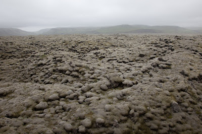
Iceland is a country of sharp contrasts - where fire and ice coexist because of the volcanoes and glaciers, and where the light from the sun is seen all day and night in the summer, and the darkness of the night is an almost all day experience in the winter. West Iceland experiences relatively mild winters due to the Gulf Stream (they say the winters in Reykjavik are about the same as in NYC), with the summers being in the 50s and 60s. My initial (and continuing) thoughts about Iceland are that it looks like it's the end of the world and the apocalypse is upon us. There is lava EVERYWHERE!


We arrived around 6:15am after a short flight for an overseas trip. After getting our rental car we hit the road old school with no GPS and only a map at our disposal. The roads are so easy to navigate (there aren't too many!) and the signage is pretty well posted. We passed through lava fields surrounded by not so distant mountains that were speckled with tiny waterfalls. At times it felt like we were alone on the road in a vast sea of lava. Simply spectacular.


Our first night in Iceland was on the Westman Islands (Vestmannjayeer). The ferry to the island was about 2.5 hours away from the airport so we had plenty of time to stop at a few things beforehand. About 10 minutes away from the ferry is Seljalandsfoss waterfall. The Icelandic term for waterfall is "foss" and this waterfall did not disappoint. We were able to get up close and personal as we were allowed to climb up and walk behind the waterfall. The mist of the water sprayed on us as we walked around, looking at it from all directions. A very cool sight indeed!


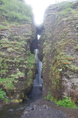
We walked about 1/3 mile to another waterfall called Gljufrabui, which means "Dweller of the Gorge" We were able to get very close with this one! It's about 40 meters high and because there's a big rock in front of it (and a little bit of a walk from the more popular waterfall) not many people notice it. You can wade through the gorge and jump on the rocks on the river (which is what we did) or walk up the rock to see the top.


It was time to head to the ferry so we got in the car and drove about 15 minutes to the ferry terminal. The weather wasn't the best so we opted to stay inside and and chill, where we ended up passing out for a good portion of the 30 minute trip! The rest of the day is a little bit of a blur... we went right to the hotel, and after checking in and having a delicious lunch at a local favorite restaurant, we took a nap to catch up on some sleep before dinner (which was spectacular).

An appetizer - I forget what was under the scallop, but it was GOOD! 

Another appetizer - smoked puffin on the left and gilamott on the right 

After getting about 10 hours of sleep (when does that ever happen??) we awoke to a gorgeous sunny and warm day on the island. Luckily we were able to sleep through the daylight the night before since we brought our eye masks - the hotel (or any other place we stayed) didn't have black out curtains. At this time of year the sun doesn't set until 11:45pm and it rises around 2:50am. During those three hours the sky doesn't even come close to being black! It's a pretty weird feeling... but more on that later on when we watch the midnight sunsets at the end of the trip.

Taken from our hotel room at around 10:45pm
The Westman Islands are a series of islands south of the mainland formed by eruptions about 10,000 years ago. Only one island, Heimaey, is habitable, and it came to international attention with the eruption of Eldfell volcano in 1973. The eruption lasted about 6.5 months and destroyed about 1/4 of the island, while increasing the size by 20%! Luckily everyone was evacuated quickly so no one was killed. Families came back to the island to rebuild, and now climbing the volcano and visiting the museum is a pretty big attraction there (along with puffin watching).


Heimaey 
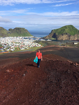
After breakfast we set out on a clearly marked path towards the volcano Eldfell. They call this area the "Pompeii of the North" due to so many houses and other structures being buried (and most likely preserved) in mounds of lava. We walked past those memorials of houses and schools that were buried 16 meters below where we stood. We continued to get nice views of the town as we walked through the 40 year old lava on either side of us on the way to Eldfell. On our walk we learned that heat from the volcano provided the town of Heimaey with geothermal energy from 1976-1985!


The path met the road a few times. 


We started the somewhat steep climb on the collapsed northern end of the volcano taking breaks to snap pictures of the gorgeous view.


Looking back at the other volcano, Helgafell 


We made it to the top and it was worth it! Once we got up there the wind hit us and all we could do was stand out facing the ocean with our arms stretched way out. We could basically see the entire island, including the teeny tiny airport. We were also able to see the other small islands that make up Vestmannaeyar. This was such an incredible view and was a great start to our week in Iceland.


We made our way to the town and walked to Eldheimer, which is a museum detailing the 1973 eruption and life on the island before and after it. The museum incorporates one house that was excavated and is still intact, including toppled household items left behind. The museum is beautifully done and we learned so much about the island.

The "buried" house

Jon putting together a puzzle.. Good Job! 

The museum 
Before we knew it we had to board the ferry again in order to continue our journey (but not before stopping at a delicious local restaurant for some lunch)!


We came to the island on the recommendation of my second cousin Rob who lived in Iceland for two years. We're so glad that we researched it and spent the night in this quaint and quiet fishing island. It was a fantastic way to start our adventures! Next up, our drive to Vik including a big waterfall, an old Navy plane crash on the beach, a sizable glacier, and Reynisdrangar rock formations in Vik!